

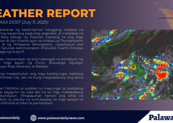
With the southwest monsoon still holding firm over much of the country, the state weather bureau warns that the heavy rains once concentrated in Luzon are now gradually shifting south, bringing wetter days ahead for MIMAROPA, particularly in Palawan.
In its July 10 briefing, the Philippine Atmospheric, Geophysical and Astronomical Services Administration (PAGASA) highlighted the changing behavior of the hanging habagat, the seasonal wind that brings with it weeks, sometimes months, of persistent rain.
“Patuloy pa rin po ang epekto ng southwest monsoon or hanging habagat sa malaking bahagi ng ating bansa,” said PAGASA weather specialist Benison Estareja, describing how the weather system continues to dominate the country’s forecast.
But this week, the spotlight is no longer just on Metro Manila or Northern Luzon.
“Subalit kung mapapansin natin ‘yung ating latest satellite animation, nagshi-shift ‘yung malalakas na ulan from areas sa western section ng Luzon, pababa rito sa may Visayas and Mindanao,” Estareja explained.
Among the regions directly affected is MIMAROPA, which emphasized the high likelihood of moderate to heavy rains over nearly the entire region, with localized thunderstorms not being ruled out.
“Simula po ngayong hapon hanggang bukas ng madaling araw, mataas po tyansa ng ulan dito sa may Visayas, Mindanao, halos buong MIMAROPA, at maging dito rin po sa mga probinsya ng Zambales, Bataan, Cavite, Batangas, Metro Manila, paakyat ng Batanes and Babuyan Group of Islands,” he said.
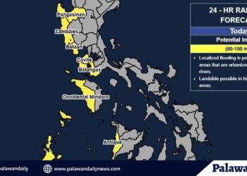
For low-lying towns in Palawan, where infrastructure is often vulnerable to even moderate flooding, the warning could mean another round of disrupted transport, delayed cargo, and flooded roads. Local disaster officials have been advised to stay alert.
While monsoon rains are seasonal and expected, the pattern shift brings new concern for southern provinces, many of which are still recovering from earlier weather disturbances.
Palawan, often regarded as the country’s last ecological frontier, is particularly prone to flash floods during consecutive days of rain, a risk now compounded by the shifting monsoon belt.
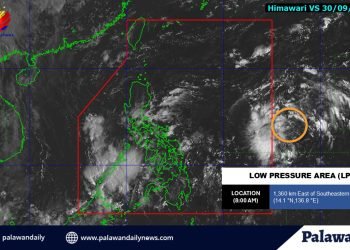
Meanwhile, PAGASA is monitoring three low-pressure areas (LPAs) near the Philippine Area of Responsibility (PAR). While none pose an immediate threat, Estareja noted that the developments are worth tracking, especially in the context of a prolonged habagat season.
“Samantala, base rin sa ating latest satellite animation, mayroon po tayong namamataan na hindi lang isa kundi tatlong low-pressure area sa paligid ng Philippine Area of Responsibility,” he said.
One of them is the remnants of Tropical Cyclone Danas, which has since weakened into an LPA and is now looping just outside the PAR.
“Nandito palapit sa ating Philippine Area of Responsibility, kung mapapansin po nila nagkaroon ng pag-ikot o looping direction po ‘yung movement nitong low-pressure area pero wala na siyang direct effect sa ating bansa,” Estareja noted.
The second LPA exited PAR Thursday afternoon and was last located 830 kilometers northeast of extreme Northern Luzon. PAGASA said it has a moderate chance of developing into a tropical depression.
The third system, farther out at more than 2,100 kilometers east of Batanes, has a higher probability of intensifying into a storm, but is not expected to enter the country’s territory. “Kung saka-sakaling maging isang bagyo ay hindi naman papasok ng Philippine Area of Responsibility,” Estareja said.
He concluded with a reminder: “Itong tatlong low-pressure areas ay walang direktang epekto sa ating bansa.”
As monsoon rains bear down on MIMAROPA, particularly in Palawan, residents are bracing for the familiar challenges of the wet season, flooded roads, stranded passengers, and the quiet halting of movement between islands.
In far-flung communities, even a single day of nonstop rain can mean canceled trips, delayed supplies, or hours of waiting for waters to recede.
The habagat is no stranger to these parts, but its changing path and timing in recent years are becoming harder to ignore. What used to be a predictable stretch of gray skies and strong winds now arrives in bursts, more erratic, more intense, and less forgiving.


